Geological history
“My face is the land.”
Dan George, Tsleil-Waututh First Nation chief,
stage and screen actor, writer, raconteur, 1982
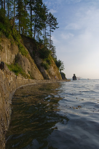
Image: Flickr [boring_vanner]
T he land space that was to become Vancouver is distinctive from the surrounding coastal environment. The present city lies on sediment that was deposited 40-70 million years ago. A subsequent drumlin[1] uplift caused by tectonic forces pushing up against the nearby Coast Mountains has left high points such as Stanley Park, Queen Elizabeth Park, the downtown escarpment (largely disappeared), and Point Grey.
The neighbouring coastal mountains wrap around and isolate the city’s footprint (and the Lower Fraser Valley) from the interior, forcing it to look seaward. The relatively new flood plain to the south is a delta that has been silting in for several thousand years[2].
This area was buried under a two kilometer thick slab of ice for several millennia, but long before the ice had entirely disappeared 5000 years ago First Nations people began appearing in the rain-soaked area to exploit the returning flora and fauna.
First Nations Settlement
“I was born at Snauq, the old Indian village under the Burrard bridge. When I [was a] little boy I listen [ed to] old people talk. Old people say Indians see first whiteman up near Squamish. When they see first ship they think it [was] an island with three dead trees…”
August Khahtsahlano, 1932 (Early Van.)

Image: City of Vancouver Archives. [CVA 1376-90]
Approximately 8000 years ago, groups of First Nations began harvesting salmon in the Fraser Canyon, and for 3000 years they exploited the resources of the future Vancouver area. One of the three Salishan groups[3] that have overlapping claims to the Vancouver area as a traditional territory is the Squamish (Skwxwú7mesh), whose territory expanded from Howe Sound to include False Creek and Burrard Inlet. Their major settlements were Whoi Whoi (Xwáýxway) in Stanley Park, Snaug (Senakw)[4], near the present day Burrard bridge on False Creek, and Xwemelch’stn at the mouth of the Capilano River. The other two groups, which shared the Halkomelem [Salishan] language, were the Tsliel-waututh and the Musqueam (Xwméthkwyiem). The Tsliel-waututh, whose plankhouse village was at the mouth of Taylor Creek on the north side of Burrard Inlet, shared the resources of the area through marriage or other uniting relationships. The complex social organization of the first peoples was based on an accumulation and redistribution of wealth[5]. Such wealth and potentially sticky political issues were kept in check by intermarriage and potlatching[6]. Failing that, occasional armed conflict was resorted to.

opposite Vancouver, B.C.
Image: City of Vancouver Archives [P28N11]
Trade with the coast was carried on by large dugout canoes and with the interior via foot trails. Large and small villages came and went but, from the later 1700s, waves of exotic diseases brought from other continents had reduced the population significantly, causing necessary consolidation to fewer, often seasonal, food gathering sites.

Image: City of Vancouver Archives [SGN 437]
The first recorded encounter between First Nations and non-First peoples was from ships by the Spanish[7] and English[8] in 1791 and 1792 respectively. Both groups were primarily interested in mapping the heavily forested area for their imperial masters and by all accounts the encounters between the natives and the people on the large wooden “floating islands” were amicable[9]. Records, however, indicate that the map makers were relatively disinterested in the area.
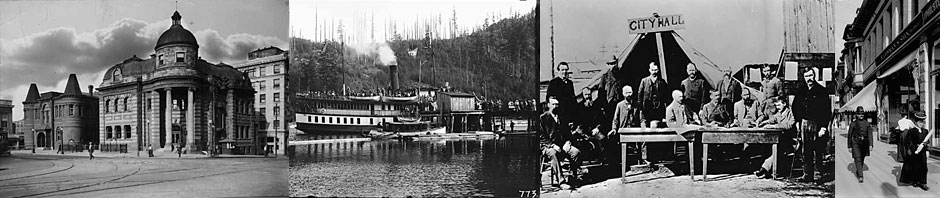
Non-native settlement and activity before it was a city
“…when there were logging injuries, the patient was tenderly laid in a canoe and paddled ten hours to New Westminster.”
A pioneer’s reminiscences of Gastown, 1872 (Early Van.)“My father, Peter Bilodeau, …arrived…[at] Hastings Mill May 2nd [1873]. There were nine white men working in the mill, and they turned out about fifteen thousand feet per day. About fifty people here.
Dr. Bilodeau, Vancouver, May 1932 (Early Van.)

Cleared by Philip Oben, who died in Central Park, 1932.
Image: City of Vancouver Archives. [CVA 677-516]
By 1800, the landmass between Burrard Inlet and the Fraser River still held little strategic value to outsiders. The American-dominated maritime fur trade continued to by-pass the area, and the Lewis and Clark 1804-06 expedition to connect eastern North America with the Pacific Ocean focused its aims further south. In 1808, Simon Fraser’s perilous ride down the Fraser River[10] ruled out the river as a conduit to the interior for the Montreal-based North West Company. Similarly,an equally terrifying voyage down the Fraser River in 1828 by the Hudson’s Bay Company’s (HBC) governor George Simpson[11] persuaded him to rule out the newly built Fort Langley, 25 km upriver from the Vancouver area, as a future Pacific headquarters for the HBC. That role went to Fort Vancouver [WA] on the north side of the Columbia River which, for the next two decades, became the focus for European and international economic activity in the Pacific Northwest. British claims on the territory were secure enough, even if British economic and social activity along Burrard Inlet was slight.

Image: City of Vancouver Archives. [Str P83]
Whereas creation of the international border between the United States of America and British North America in 1846 isolated the lower mainland from any natural geographical north-south orientation, it was the Fraser River gold rush of 1858 that dramatically reshaped the Vancouver area. The network of First Nations foot trails and fur trade-era foot and brigade trails[12] could not carry the tens of thousands of unruly outsiders attracted by the gold rush into the interior nor could the Colonial Office in London leave such chaos in the hands of the HBC. London hastily chose to create a new crown colony on the mainland called ‘British Columbia’. Hard on the heels of this declaration came the imposition of a new social, political, cultural and geographic order.
In 1859, from the newly built colonial capital of British Columbia at New Westminster, the Royal Engineers (RE) set out to survey various areas, including Burrard Inlet. That same year the RE punched through a strategic military (escape route) trail, North Road, from New Westminster to Burrard Inlet and in the following year created a trail that became Kingsway, from New Westminster to False Creek.
From 1859, all land within British Columbia was proclaimed as belonging to the Crown, and in the following year British subjects could pre-empt land (160 acres or 65 hectares at a time) not set aside for Native settlements (established at 10 acres or 4.1 hectares per person), townsites or military reserves. The future city of Vancouver thus became a checkerboard of Native settlements, military and other Government Reserves, plus district lots claimed by individuals and groups.

Image: City of Vancouver Archives. [CVA677-228]
The first Vancouver Military Reserve, now Stanley Park, appeared in 1859-60, when Col. Richard Moody set aside the peninsula’s strategically placed uplift for military purposes. Here, in the 1860s and 1870s, the workers from the Hastings Sawmill a few kilometers to the east created an unorganized graveyard along the shores to bury their dead. As well, ship jumpers with Native wives began settling along its shores.[13]
One of the first district lots, the “Bricklayers’ Claim,”[14] now today’s West End, was pre-empted by three individuals who in the spring of 1862 claimed 160 acres each to form the whole. Soon, several Hawaiian families took up residence on the Coal Harbour side.[15] When brick-making prospects failed to materialize the three eventually parted ways and sections of their three-way claim were sold to various interests.[16]
Also in 1862 on the north arm of the Fraser River in what was to become South Vancouver, the two McCleery brothers each took on 160 acres of pre-empted land. There they started a productive vegetable and dairy farm with cattle brought in from Oregon.[17]
RE surveyors plotted out more than one townsite. In 1863 they surveyed a seemingly ideal Government Reserve Townsite (later called Hastings). In anticipation of rapid growth, later 1869 surveys from Nanaimo Street to Boundary Road generously apportioned 30 meter (99 feet, or 1.5 surveyor’s chain) wide streets as befitting a future city centre. The site, which served as a recreational area for New Westminster residents, boasted the city’s first hotel, wharf, post office, museum, and subdivision. However, a more natural commercial draw to the west spelled doom for Hastings Townsite.

Image: City of Vancouver Archives. [P166]
A second townsite grid to the west was the Granville Townsite which included Gastown. In 1870, the RE laid it out from Coal Harbour to False Creek. The area took in hotels and bars constructed to be near the Hastings Mill and the inhabitants named the area Gastown after the loquacious bar owner “Gassy” Jack Deighton. Ironically, after a more ordered townsite survey was completed, Deighton’s bar was found to be in the middle of a road. This area nonetheless became the focus of activity both socially and economically. By the 1870s the medley of workers in sawmills on both sides of Burrard Inlet included representatives from a variety of First Nations from the coastal region and sixteen or more other immigrant nationalities.[18] The workers at the Hastings Mill, established in 1865 on the south shore of Burrard Inlet, were provided books at the Hastings Literary Institute, the forerunner of the Vancouver Public Library. By 1884 business had expanded to the point where wooden beams over 37.2 m or 122 feet long were shipped to the Imperial Palace in Beijing.

Image: City of Vancouver Archives. [Str P8]
Development was slow in this checkerboard that was to be Vancouver. What was needed was a catalyst for a major city to take root and bring together all its disparate parts.
- A drumlin is a long low oval mound of compacted boulder clay rounded and smoothed by glacial action.↵
- This area includes neighbouring cities as Richmond, Delta, Surrey and others↵
- The Salishan-speaking First Nations people comprise 23 separate and distinct yet related languages and many more dialects within an area which covers southern British Columbia, Washington, Oregon, Idaho and Montana. Culturally, the Salishan people can be roughly divided into two groups, coastal and interior. As the various languages involve glottalizations and lengthy consonant clusters without vowels, a roman script by itself is an inadequate orthography to transcribe such complex sounds and so other symbols have been added over the years. Early attempts to put the language into written form have left a variety of transcription types. Within the Vancouver area, two separate Salishan languages existed side by side, the Squamish and Halkomelem (Musqueam and Tsliel-waututh).↵
- According to tradition, this settlement claim overlaps with the Musqueam First Nation.↵
- Ownership of slaves was also considered part of wealth accumulation and class structure although, unlike more northerly coastal First Nation groups, slavery in this area was a less important part of the culture.↵
- A potlatch served to act as a social and economic display as well as serving as a mechanism for redress and/or the redistribution of wealth.↵
- On July 1, 1791, a 23 year-old Spanish naval first mate (segundo piloto havilitado), José Maria Narváez (1768-1840), took command of the 12 meter schooner Santa Saturnina (and a longboat from the frigate San Carlos) to explore Georgia Strait (Canal de Nuestra Señora del Rosario) and sailed into Burrard Inlet that same month. His largely Mexican crew of 22 would have included someone to record the topography as well as the flora and fauna. It may also have included a priest, which was standard on such voyages.↵
- In 1792, 35 year old English naval captain, George Vancouver (1757-1798), who had sailed with James Cook between 1772-1780, returned to the Pacific coast as expedition leader commanding the 297-tonne Discovery which was accompanied by the Chatham. Like the Spanish, most of the exploration was done from longboats while many of the 150 crew stayed aboard ship farther from the shore. When Vancouver met the Spaniards off Point Grey in July 1792, he was horrified to find that the Spanish had already mapped the Vancouver area the year before. Like Narváez, Vancouver sailed into Burrard Inlet, coming ashore at Brighton Beach. Vancouver gave English names to locations already named by the Spanish: for example, Punta de Langara became Point Grey, Boca de Florida Blanco became Burrard Inlet, Isla de Zepeda became Point Roberts, and Canal de Nuestra del Rosario became Georgia Straight, after King George III of England.↵
- James P. Delgado, Waterfront, 12. .↵
- “June 26, 1808…I have been for a long period among the Rocky Mountains, but have never seen any thing equal to this country, for I cannot find words to describe our situation at times. We had to pass where no human being should venture.” Simon Fraser, Letters and Journals, p. 96. Fraser made it past the Musqueam village in July 1808 but turned back because of hostility brought on by the fact that he had taken a canoe upriver without permission and that the local peoples were involved in on-going altercations with their neighbours, an unhappy mix of events.↵
- “Frasers River, can no longer be thought of as a practicable communication with the interior…I should consider the passage down, to be certain Death, in nine attempts out of Ten.” Simpson’s 1828 Journey to the Columbia, p. 38-39↵
- Charles Hou, The HBC Fur Brigade-First Nations Trail of 1848-49.↵
- Anywhere from 85 to 200 burials took place between the present Nine O’Clock Gun and Brockton point lighthouse. All living settlers along the shores of Stanley Park and Deadman’s Island were eventually removed..↵
- District Lot 185 or the Three Greenhorns’ Claim. The Three Greenhorns were three Englishmen, John Morton, William Hailstone and Samuel Brighouse, who, after attempting to find gold in the Cariboo, pre-empted land for what was thought at the time to be an inflated price and so were given the name “The Three Greenhorns” for their naivete↵
- Hawaiians had been working in both the maritime and land-based fur trade mainly along the coast since 1787. A large number chose to settle. A few who came out of the HBC, chose local wives, and settled at Kanaka Ranch on Coal Harbour were Eihu, Joe Nahanee, James Keamo and Nahu. Barman, see Stanley Park Secrets, 46-57.↵
- J. S. Matthews, Early Vancouver, 81↵
- Lisa Smedman, Vancouver: Stories of a City, 105-106; one brother acquired the lot from his uncle who had pre-empted it in the spring of 1862, and the other brother pre-empted the neighbouring lot. Derek Hayes, Historical Atlas of Vancouver, 62.↵
- Musqueam, Squamish and Tsel-waututh as well as “Portuguese, Chilean, Hawaiian, Russian, Finnish, Austrian, German, Dutch, Spanish, French, Belgian, Swedish, American, English, Irish, Scottish” and free American blacks. Delgado, Waterfront, 35.↵